2 Aldığı Oy (5.00 Ortalama) ve 5.380 Görüntülenme  

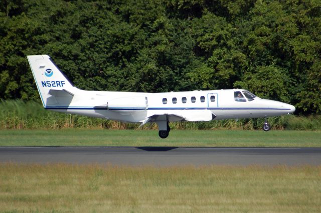
Cessna Citation II (NOAA52) - The Cessna Citation (CE-550) is a versatile twin-engine jet aircraft modified for acquiring remote sensing imagery. The aircraft is equipped with two equal sized camera ports which can support a wide variety of remote sensing configurations including large format aerial photography as well as data collection for digital cameras, hyperspectral, multispectral, and LIDAR systems.     Standard configuration includes space for two pilots, two equipment operators, and a scientific equipment rack. The aircraft can accommodate additional passengers depending on the amount of scientific equipment. The aircrafts unique side-by-side sensor port modification allows two different sensors to collect data simultaneously. The sensor ports have glass optical flats that allow the cabin to remain pressurized. Additionally, two high-precision GPS antennas provide signals to user receivers.     The Citation primarily supports the Remote Sensing Division of the National Geodetic Survey, collecting remote sensing data in support of coastal mapping and remote sensing research. Imagery acquired onboard the Citation is used for updating the shoreline and shore features on NOAAs nautical charts. The Citation also serves as an emergency responder during hurricane season by collecting digital photography of damaged areas caused by hurricane landfall.
/images/icons/csMagGlass.png orta / geniş / tam

Cessna Citation II (NOAA52)

eklendi

The Cessna Citation (CE-550) is a versatile twin-engine jet aircraft modified for acquiring remote sensing imagery. The aircraft is equipped with two equal sized camera ports which can support a wide variety of remote sensing configurations including large format aerial photography as well as data collection for digital cameras, hyperspectral, multispectral, and LIDAR systems. Standard configuration includes space for two pilots, two equipment operators, and a scientific equipment rack. The aircraft can accommodate additional passengers depending on the amount of scientific equipment. The aircraft's unique side-by-side sensor port modification allows two different sensors to collect data simultaneously. The sensor ports have glass optical flats that allow the cabin to remain pressurized. Additionally, two high-precision GPS antennas provide signals to user receivers. The Citation primarily supports the Remote Sensing Division of the National Geodetic Survey, collecting remote sensing data in support of coastal mapping and remote sensing research. Imagery acquired onboard the Citation is used for updating the shoreline and shore features on NOAA's nautical charts. The Citation also serves as an emergency responder during hurricane season by collecting digital photography of damaged areas caused by hurricane landfall.

Comments

Please log in or register to post a comment.

AKTİVİTE KAYDI
NOAA52 için 1998 yılına kadar geri giden tam geçmiş araması ister misiniz? Hemen satın al. Bir saat içinde gelsin.
Tarih Uçak Kalkış Yeri Varış Yeri Kalkış Varış Süre
No Recent History Data
Kayıtlı kullanıcılar (kayıtlı üye olmak ücretsiz ve kolaydır!) 3 months süreyle geçmişi görüntüleyebilir. Üye ol
 

Giriş

Hesabınız yok mu? Kişiselleştirilmiş özellikler, uçuş uyarıları ve daha fazlası için şimdi (ücretsiz) üye olun!
FlightAware uçuş takibinin reklamlarla desteklendiğini biliyor muydunuz?
FlightAware.com'dan gelen reklamlara izin vererek FlightAware'in ücretsiz kalmasını sağlamamıza yardım edebilirsiniz. harika bir deneyim sunmak adına reklamlarımızı anlamlı ve öne çıkmayacak şekilde tutmak için yoğun şekilde çalışıyoruz. FlightAware'deki whitelist adsreklamları güvenilir olarak görmek hızlı ve kolaydır, veya lütfen premium hesaplarımıza geçmeyi düşünün.
Kapat